
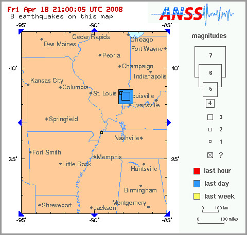
This map is from the United States Geological Survey; click here for more information on the quake.
Earthquakes are rare in eastern North America, due to the region's distance from active tectonic plate boundaries. These plates, which could be described as islands of solid rock floating on the liquid lava inside of the earth, typically cause earthquakes when they rub up against each other, as happens around the rim of the Pacific Ocean. But due to the nature of the plate boundaries, quakes there are more frequent, but also locally limited. These boundaries are so broken up due to frequent earthquakes that their mountains are almost describable as big piles of gravel — and so earthquakes, even major ones, don't affect too large of an area.
On the contrary, the rock plate in eastern North America is quite solid and continuous, so earthquakes propagate over very wide areas, causing destruction at distances hundreds of miles from the quake's epicenter. Likewise, since there is no obvious agency that predictably cause the earthquakes, nor are there distinctly mapped active fault lines, predicting and characterizing earthquakes in the region is difficult.
The earthquakes in New Madrid, Missouri, in the years 1811 and 1812, reaching a magnitude of 8.1, were among the largest in United States history. According to the USGS:
At the onset of the earthquake the ground rose and fell - bending the trees until their branches intertwined and opening deep cracks in the ground. Landslides swept down the steeper bluffs and hillslides; large areas of land were uplifted; and still larger areas sank and were covered with water that emerged through fissures or craterlets. Huge waves on the Mississippi River overwhelmed many boats and washed others high on the shore. High banks caved and collapsed into the river; sand bars and points of islands gave way; whole islands disappeared. Surface rupturing did not occur, however. The region most seriously affected was characterized by raised or sunken lands, fissures, sinks, sand blows, and large landslides that covered an area of 78,000 - 129,000 square kilometers, extending from Cairo, Illinois, to Memphis, Tennessee, and from Crowleys Ridge to Chickasaw Bluffs, Tennessee.The quake caused church bells to ring as far away as Boston and Montreal. The Daniel Boone Home, still standing in Saint Charles County, Missouri, was shifted 18 inches off of its foundation during the tremors, and an Indian military attack on Fort Bellefontaine near Saint Louis was abandoned because of the quake.
Although the motion during the first shock was violent at New Madrid, Missouri, it was not as heavy and destructive as that caused by two aftershocks about 6 hours later. Only one life was lost in falling buildings at New Madrid, but chimneys were toppled and log cabins were thrown down as far distant as Cincinnati, Ohio; St. Louis, Missouri; and in many places in Kentucky, Missouri, and Tennessee.
A quake of similar proportions today would be a widespread disaster.
Somewhat amusingly, a journalist asked me if he could use one of my photos to illustrate his article about today's earthquakes.
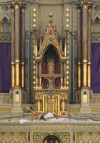
However, this is not earthquake damage.
This is a photo of the altar taken after the Good Friday liturgies at Saint Francis de Sales Oratory; it shows candlesticks and linens strewn about the altar, which symbolizes the terræmotus, or earthquake that took place during the Crucifixion of Our Lord (see Matthew 27:51).

No comments:
Post a Comment