
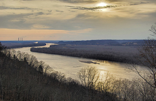
A view of the Missouri River at sunset, looking to the southwest, atop the bluffs at Saint Albans, in Franklin County, Missouri. Photo taken yesterday.
This place is mentioned in the journal of the explorer William Clark on May 23rd, 1804, on the occasion of the first American overland expedition to the Pacific Ocean:
We Set out early ran on a Log and detained one hour, proceeded the Course of Last night 2 Miles to the mouth of a Creek on the Stbd. Side Called Osage Womans R, about 30 yds. wide, opposit a large Island and a Settlement. (on this Creek 30 or 40 famlys are Settled,) Crossed to the Settlemt. and took in R & Jo: Fields who had been Sent to purchase Corn & Butter &c. many people Came to See us, we passed a large Cave on the Lbd. Side Tavern about 120 feet wide 40 feet Deep & 20 feet high many different immages are Painted on the Rock at this place. the Inds & French pay omage. many nams are wrote on the rock, Stoped about one mile above for Capt Lewis who had assended the Clifts which is at the Said Cave 300 fee high, hanging over the Water, the water excessively Swift to day, we incamped below a Small Isld. in the Meadle of the river, Sent out two hunters, one Killed a Deer...The tall bluff where Lewis fell from is on the left side of this photo; a dramatic artistic depiction of this fall can be found here. Tavern Cave still exists down at the base of this tall bluff; see this article for photos. You can just barely see Femme Osage creek in this photo. The settlement mentioned by Capt. Lewis was Missouriton, a short-lived town founded by the frontiersman Daniel Boone, which was subsequently wiped out by flooding. Click here for an historical map of the area.
This evening we examined the arms and amunition found those mens arms in the perogue in bad order a fair evening Capt. [Meriwether] Lewis near falling from the Pencelia of rocks 300 feet, he caught at 20 foot.

Mark thanks for the photo's and quick history lessons! I googled St. Albans and stumbled upon that golf course and subdivision development. Is that where all of the money in St Louis has gone???
ReplyDeleteThere are many large, comfortable, expensive homes here, although they are not of good architectural design quality - but then I have very high standards. The bulk of the construction here is concentrated in the Tavern Creek valley below and so there are lots of trees and rugged hills surrounding it.
ReplyDeleteSome of the older buildings here - from a century ago - are quite charming and rustic, including the simple old frame buildings in the center of the development, as well as high-design rustic stone buildings of a past age.
St. Albans is isolated from west Saint Louis County. Public roads off of Wild Horse Creek Road in Wildwood come very close to, but do not connect to Saint Albans. 2000 feet of geographical distance translate to 9 miles of road distance. The same goes with nearby wine country towns in Saint Charles County, right across the river, which are only two miles away but are at least an hour's drive.
There is plenty of rural land surrounding St. Albans, so this is most definitely a commuter suburb - with the closest concentrations of business from here being Pacific, Eureka, and Ellisville.
An oddity is that much of the bottomland next to the development is in Saint Charles County even though it is on the south side of the river, this due to flooding changing the river's course. The development itself seems to be largely safe from flooding.
You can see the Labaddie power plant in the photo, with its three smokestacks, which somewhat degrades the view.
Although this town is named after Saint Alban, the first Christian martyr in Roman Britain, there is no significant Catholic history here as far as I know. There are no nearby Catholic churches, or even Protestant congregations of any denomination for miles.