
This county is becoming increasingly suburban in the northerneastern part, but still has extensive rural areas, wilderness, and industrial towns that date from the early 19th century. This county primarily has the character of the Ozarks, and has many narrow, often dangerous, roads, and scenic vistas.
Following are extracts from Goodspeed's History, published in 1888. See http://www.rootsweb.com/~nebuffal/jeffcomo/index.htm.
A little more than a hundred years ago the territory comprising Jefferson County was the undisputed home of the wild men of the forest and the native animals. The territory however at that time belonged to Spain and was under control of a Spanish Governor, who made liberal offers of land to persons who desired to settle permanently in the county.Georgraphy:
...In 1776 St. Louis and Ste. Genevieve had become trading posts of considerable importance, but the country lying between was filled with savage Indians and wild animals, thus making a journey overland between these points extremely hazardous. Francisco Cruzat, who was the lieutenant-governor of Upper Louisiana, desirous of removing the perils of the journey, offered a donation of 1,050 arpents of land to any one who would establish and keep a ferry across the Meramec. Jean Baptiste Gomoche, a Frenchman, accepted this offer, and established a ferry across the Meramec, at what is still known as the Lower Ferry, about a mile above the mouth of that river. For this service Gomoche was granted the tract of land at the mouth of the Meramec, which includes the bridge across that stream and Jefferson Station of the St. Louis, Iron Mountain & Southern Railway. At the same time a trail was marked out on the west side of the Mississippi from St. Louis to Ste. Genevieve passing lengthwise through what is now Jefferson County. This trail was called the King's trace. It crossed the Meramec at Gomoche's ferry, and was the first highway marked out in the territory of Jefferson County.
...John Boli settled on Romine Creek in 1788. He built a log hut, and opened a little piece of land. He was driven away from his home several times by the Indians, and his cabin was burned by them. John Piatt settled on Big River, not far from P. P. Byrne's mill, prior to 1790. In that year he was driven from his home by the Indians, and he remained away till 1800, when he returned. In 1801 he was again driven away, and several of his neighbors were killed by the Indians in 1803."
In 1790 the Indians became so troublesome that the settlers organized for defense, and built a rude fortification on Saline Creek near Thomas Tyler's cabin.
James Head settled at House's Springs in 1795. He moved away in 1796, and Adam House moved on the place. House lived there till 1800, when the Indians killed him... House's son was badly wounded at the time, but he escaped, went to the settlement at Kimmswick and gave the alarm. All the settlers turned out, forming quite a company, with William Mars as captain, and they pursued the Indians, who were of the Osage tribe, on to Indian Creek, in Washington County, where they overtook them and gave them battle. The whites were victorious, killing many of the savages and driving the rest away.
Up to 1800 buffalo and elk were plentiful but with the advance of civilization these animals disappeared or kept a safe distance from the approaching settlements.
Indians were numerous. The Delawares and Shawnees lived south of this in Ste. Genevieve, Perry and Cape Girardeau, and the Osages lived near Union, in Franklin County, the Cherokees lived on White River. The Delawares, Shawnee and Cherokees were peaceable and friendly, but the Osages were very savage and warlike, and gave the settlers a great deal of trouble. In 1803 there was no postoffice nearer than St. Louis, and no road in the county. There were what were called trails from one settlement to another. There was no store here then...From 1774 to 1803 the settlers of this county did all their legal business at St. Louis; they traded and got their mail there. The currency of the people was gold and silver and dressed or shaved deer skins.
...These were the pioneers who penetrated the "western wilds" and settled amid the savage Indians and dangerous beasts, and suffered the hardships of frontier life while carving out comfortable homes for themselves, their wives and dear little ones. Many were the hardships they endured. Besides the encounters with the Indians, the dangers, fear and dread of that race, which they had constantly to endure, they were without roads, bridges, mills, blacksmith shops, and many other things so essentially necessary to the welfare and convenience of a community. Yet withal, they lived happily, save the fear and dread of the Indians. Every settler owned one gun and one dog, at least. These were considered indispensables, for without them the wild beasts would have invaded the yards and houses of these pioneers...
The men wore buckskin suits and coon or fox-skin caps in winter, and suits made from flax or cotton and straw hats in the summer. The shoes were made of buckskin tops and rawhide soles. These were called shoe packs or moccasins. The women wore home-made cotton goods, and there was great rivalry between the ladies of those days in regard to getting up new and beautiful patterns of checked and striped cotton dress goods. All the sugar then used was made at home, out of the sap of the maple or sugar trees, and coffee, being a foreign article, was so costly that the first settlers could not afford that luxury. Venison, bear meat, wild turkeys and wild honey abounded in great abundance, and those who had cows to produce milk really lived in "a land flowing with milk and honey." Bee trees filled with honey could be found everywhere, and the honey cost only the labor of getting it. Wild game was so abundant that the early settlers kept their families well supplied with it. With these meats, wild honey, wild fruits, and plenty of "hoe-cakes," the pioneer housewife could set a table "good enough for a king."
Jefferson County, Mo., is bounded north by St. Louis County, east by the Mississippi River, south by Ste. Genevieve, St. Francois and Washington Counties, and west by Franklin. It contains an area of about 628 square miles. The surface is generally hilly. The highest ridge, which extends north and south through the center of the county and forms a watershed between Big River and the Mississippi, attains elevation above the latter of about 459 feet, and from 200 to 300 feet above the neighboring streams. In the northern and western townships the ridges are very narrow at their summits, and are separated from each other by deep ravines. The hills bounding the valleys of the larger streams are also frequently marked with deep declivities, but sometimes they rise by a succession-of gentle slopes or terraces to the general level of the table-lands. East of the central ridge, the county is drained by the Meramec River, Little Rock, Glaize, Sandy, Joachim, Muddy, Isle au Bois and other creeks, which flow into the Mississippi. The western part of the county is drained by Big River, which flows in a tortuous route from the southern to the northern boundary of the county, where it empties into the Meramec. The principal tributaries of Big River are Dry Fork, Belew, Head and Jones Creeks. A part of the northern portion of the county is drained by Saline, Sugar, Mill and Labarque Creeks, which also empty into the Meramec. Thus all parts of the county are well watered. Many springs, producing water unsurpassed in quality, abound, and some of them, especially at Kimmswick and Sulphur Springs, are considered valuable for their medicinal qualities. Water is also obtained from wells of moderate depth, but many people prefer and use cistern for family purposes.Description of the mineral wealth:
The table lands of the county are moderately rolling, and possess a good soil composed of sand, clay and humus, supported by a red clay subsoil. The soil in the valleys is alluvial and exceedingly productive. The timber on the uplands consists principally of the oak in its several varieties and hickory while on the lowlands and along the streams it consists of sycamore, maple, hickory, walnut, oak, buckeye, cottonwood, etc.
Stone for building purposes and the finest quality of sand for the manufacture of glass exist in inexhaustible quantities. Everywhere in Jefferson County the natural scenery is beautiful, and along the Mississippi and the Iron Mountain Railroad it is exceedingly picturesque.Horticulture:
The mineral resources of Jefferson County have only been partially developed. Iron and zinc exist in considerable quantities, and the deposits of lead are so extensive as to appear inexhaustible. The latter is the great mineral product of the county, and the only one that has been developed to any considerable extent.
Formerly the farmers of Jefferson County paid much attention to horticulture. Extensive orchards were planted, and fruits of all kinds were extensively raised to supply the St. Louis market. For a number of years last past the yield of fruits, especially in regard to peaches, has been so limited that the farmers have become somewhat discouraged, and have partially relaxed their efforts to produce them. The climate being moderately mild, and the soil and locations so well adapted to the growing of orchards, and good markets so near at hand, with constantly increasing demands, there is no doubt but that horticulture will soon become a leading and profitable industry of Jefferson County. For many years past, and at the present time, grapes have been and are now extensively cultivated. The most numerous and most extensive vineyards exist in the northeastern part of the county and along the line of the Iron Mountain Railroad. In Rock Township, which lies nearest to the city of St. Louis, nearly every farmer has a vineyard. This industry was introduced and has been followed mostly by the German citizens. The leading varieties of grapes cultivated are the Concord, Northen's Virginia Seedling, and Ives Seedling. The first is cultivated both as a table and wine grape, and the other two mostly for wine. A very large quantity of domestic wine of superior quality is annually manufactured in the county; the greatest amount at any single point being made at Bushberg, on the Mississippi, and on the railroad twenty-five miles from St. Louis. Facilities for propagating grape vines and for the manufacture of wines have existed at this place and been successfully operated for many years.Mills:
Since the completion of the Iron Mountain Railroad, the cutting and shipping of cord-wood to St. Louis has been and still continues to be a permanent industry all along the line. Along the immediate line of the railroad the supply of wood is being exhausted, but vast quantities still exist remotely from the line. A few portable sawmills are used in the county, where timber in suitable quantities exist, but the cutting of lumber is mostly for home use, and is not a very prominent industry. The county is well supplied with gristmills, the most of which are along the line of the railroad, and on Big River. Along the course of the latter, beginning at the north, is the mill of James Byrnes, three miles northwest of House's Springs; another, owned by Henry Vandecrusen, on House's Springs Branch, one mile west of the village; then comes the mill of Michael Byrnes, five miles southwest from House's Springs; and next, Lewis Snair's mill, one mile farther in the same direction; then comes John H. Morse's mill, at the southern terminus of the Big River gravel road, and seven miles northwest of Hillsboro. Another mill, and one of the oldest in the county, is Cole's mill, on Joachim Creek, near Valle Mines. Pleasant Valley Mills are located near Peverly.
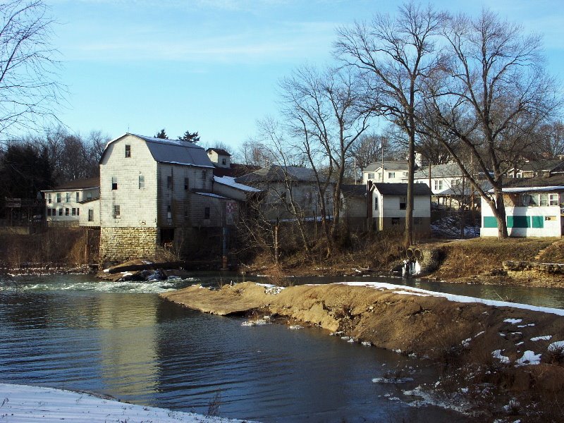
Cedar Hill Dam on the Big River in Jefferson County, Missouri
Remoteness:
Judge Thomas, in his centennial address, said: "Politics did not trouble our fathers much. Prior to 1804 there was no voting in this section. The King of Spain governed us, or, rather, let us alone. After 1804 the capital of the country 1,000 miles from them, and the way to it was through a trackless wilderness. The news of the election of Thomas Jefferson as President of the United States did not reach the people here for four months after the election. There was no newspaper published within hundreds of miles of them."War:
Prior to the late Civil War no organized bodies of soldiers were raised in Jefferson County... On the approach of the war of 1861-65, between the States of the Union, it is believed that a large majority of the people of Jefferson County were in favor of State sovereignty, and were in sympathy with the Southern cause, but not to that extent as to make them in favor of secession...the Union delegates carried Jefferson County by an overwhelming majority, thus showing a strong opposition to secession. The people of Jefferson County preferred to remain in the Union, and, if possible, maintain State sovereignty and State neutrality.Roman Catholic Church:
With these preferences in view, a meeting of the citizens was held at Hillsboro early in the spring of 1861, when speeches were made and a flag, with a State's rights motto inscribed upon it, was raised. Great excitement then prevailed, and the news soon spread abroad that a secession flag had been hoisted at Hillsboro. This was believed by many who were not in attendance at the meeting and who were not acquainted with the facts. After the National flag had been fired upon at Fort Sumter, and President Lincoln had issued his first call for troops, the sympathy in favor of the South grew stronger, and a call was made for a public meeting to be held at De Soto, on the 16th day of May following. A pole was raised, and on that day a flag, with a single star, emblematic of State sovereignty, was to be suspended thereon. It was understood that this meeting was to be composed of those who were in deep sympathy with the southern cause. Accordingly, on the morning of the day appointed, the citizens began to assemble at De Soto, and a company of seventy-five mounted men, from St. Francois County, were on hand. At this juncture a railroad train, with a company of Union troops, under command of Capt. Nelson Cole, arrived from St. Louis. When these soldiers began to emerge from the cars the men from St. Francois County mounted their steeds and quietly retired, and thus avoided a collision. The flag had not yet been raised, but the soldiers at once cut the pole down, and then began a search for the flag, and the meeting called for the occasion was "declared off." The flag was finally found, after a lady, who was trying to conceal it, had sat on it nearly all day. On the same occasion a detachment of Cole's company went to Hillsboro to capture the so-called secession flag that had previously been raised at the former meeting held at that place, and when they found it they declared it was not a "secession flag," and that it was good enough for them, and at once ordered it to be raised with the injunction that it should be protected. After being much worn it was taken down, and having become historic, it passed into the possession of the ladies of the vicinity, many of whom soon had a piece of it in their bed quilts.
Capt. Cole's men were the first soldiers who performed service in Jefferson County during the Civil War. No organized body of men went into the Confederate army from Jefferson County during the struggle, but it is estimated that nearly 200 individuals, from first to last, went out of the county and joined various Confederate commands, including those who went into the State Guards, where they served only a short time.
The early and subsequent occupation of the county by the Federal authorities gave an opportunity for the formation of companies for the United States' service, the first one of which was organized in June, 1861, and mustered into the service as Company B, Sixth Infantry, Missouri Volunteers...
No regular engagements between the contending armies took place in Jefferson county during the war. Late in 1861, Jeff. Thompson, of Confederate fame, with his command, burned the Iron Mountain Railroad bridge across Big River, on the line between Jefferson and Washington counties. A very slight skirmish took place on the occasion. Though the county was occupied nearly all the time by the Federal authorities, an occasional Confederate scouting party passed through it. In the fall of 1864, when Price made his raid into Missouri, a small command from his army took possession of De Soto and destroyed some property, and then left without further damage. During the war some atrocious things done by certain Union troops...[citizens] were killed and wounded for no other crime, it is said, than that of being Southern sympathizers; and the atrocious act of inflicting such punishment was and has always been condemned by all good citizens of both contending parties.
According to the census of the United States there was one church of this denomination in Jefferson County in 1850. Undoubtedly it was the one known as the Church of the Immaculate Conception, which is located about one-half mile east of Maxville. A Roman Catholic Church, called "St. Rose of Lima," was organized some years ago at De Soto, and a frame edifice, still standing, was erected. Since then a large stone church of modern architectural design has been built. The latter was dedicated June 21, 1885, by Very Rev. P. P. Brady, V. G. of St. Louis. The Fathers of this church, beginning with 1871, are as follows: Rev. H. Jaegering, 1871-73; P. J. McNamee, 1873-81; C. F. O'Leary, 1881-86; Rev. J. A. Connolly, since 1886. The membership embraces about 120 families. There is a Roman Catholic Church near Kimmswick and another at Festus--the former has been organized many years, and the latter only a few years. There is also one in Rock Township, three miles east of High Ridge. The membership of this church is composed of Bohemians. A brick edifice was built one mile west of Byrnesville, about the year 1869. Becoming unsafe it was taken down in 1887, and a frame building erected in its stead.
The "St. Joseph Convent," a large two-story stone building of very fine architectural appearance, was built by the Roman Catholics in the bosom of the La Barque Hills, three and a half miles northwest of Byrnesville. There is also a chapel connected with it, and a priest resides there. This institution is located in a very secluded place, surrounded with the most magnificent natural scenery. [Note: this is now the Black Madonna Shrine]

I reside next to and my family owns the first bank and post office of house springs. The building looks like a mini castle. It awesome and yes we live in one of the most beautiful places in the world.
ReplyDeleteTill you ruined it spray painting it and making it a head shop. Clean up your lots
DeleteI have been looking for Yates Cemetary, in Rock Township. My first generation, as far back as I can research, is buried there. Any help locating this old graveyard would be appreciated
ReplyDelete